Meadowgreen
Saskatoon Neighbourhood – Meadowgreen
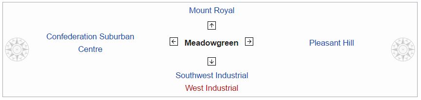
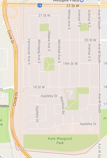 Meadowgreen community is a geographically localized subdivision of the Confederation Suburban Development Area in the city of Saskatoon. Meadowgreen is surrounded by an abundance of green space and walking trails without being a River side neighbourhood. The buffer zone along Circle Drive has a newly created walking trail. The southern buffer zone along 11th Street connects to the east with Fred Mendel Park of the Pleasant Hill neighbourhood and to the west with the off leash dog run located in the Confederation Suburban Centre neighbourhood. As well the newly re-located Meadowgreen Park and Peter Pond Park provide leisure activities such as basketball courts and playgrounds. Within the Confederation SDA of Saskatoon, the neighborhood of Meadowgreen comprises the area south of 22nd Street, north of the buffer zone between 11th Street and Appleby Drive, east of Circle Drive, and west of Avenue W South. Until the 1990s the portion of the community north of 18th Street was considered part of the Pleasant Hill community until the City of Saskatoon reorganized its community boundaries.
Meadowgreen has a little higher population in its neighbourhood 3,860 compared to Adelaide/Churchill at 3,535. A nearby community of Mount Royal is the next largest of Saskatoon’s subdivisions at 4,110 persons. There are 3,860 people living in this area of Saskatoon, with the 34% of this population being employed in sales and service, the main occupation of this neighbourhood. The average income as of 2006 was $37,541 enabling an average house market value of $105,527. 770 of the 1,560 homes are detached residences, the majority built between 1960 and 1980. According to MLS data, the average sale price of a home as of 2013 was $220,928.
Layout – The area south of 18th Street, north of the buffer zone between 11th Street and Appleby Drive, east of Circle Drive, and west of Avenue W South is laid out in a court system. The northern portion is laid out grid fashion; avenues run alphabetically north and south, Streets run numerically east and west. After Avenue Y South, the Avenues are named after Canadian Cities such as Montreal, Ottawa, Winnipeg and Vancouver. Witney Avenue is the only anomaly to the naming convention, and is named in lieu of having an Avenue Z. Prior to the construction of the Circle Drive and 22nd Street interchange, motorists were able to access the Fairhaven neighborhood from Meadowgreen via 18th Street through a signalized grade crossing intersection at Clancy Drive and Circle Drive, and also off Circle Drive via 20th Street. Prior to a heated debate, the initial plan called for the intersection of 18th Street/Clancy Drive and Circle Drive to remain as the interchange called for no access to eastbound 22nd Street from southbound Circle Drive as the 20th Street intersection would cease to exist when construction started. Fearing an increased volume in traffic along 18th Street, a re-drawing saw a leg of Camponi Crescent become part of the interchange and access to 18th Street from Circle Drive would cease to exist, leaving access to Circle Drive from either 11th or 22nd Streets. The 18th Street/Circle Drive intersection was closed to traffic in 2001, and all traces of the roadway between Circle and the CN rail line were permanently removed in 2002, however the signalized grade crossing intersection at Circle Drive and Clancy Drive remains as it was reconfigured to a layout similar to that of the intersection of Circle Drive and Laurier Drive following the closure of 18th Street. The net result is there is currently no direct access to Meadowgreen from the west; however 18th Street could possibly be reconnected if an overpass/interchange is ever constructed at Circle and Clancy.
History – The land for Meadowgreen was annexed by the city of Saskatoon between 1955 and 1959. Approximately 33% of the dwellings were built in the 1960s, and 45% built in the 1970s.
Education – W.P. Bate School was originally located at 342 Ottawa Avenue South. It opened in 1961 and was named in honour of William Pope Bate (1866 – 1934), who had been a long-time secretary-treasury of Saskatoon Public Schools in its early days. In September 2006, the school relocated to a new location at 2515 18th Street West. The school namesake, W.P. Bate, homesteaded nearby at NW Section 24 Township 36 Range 5 W of the 3rd Meridian, provisional district of Saskatchewan, North West Territories and received his dominion land grant patent Oct 31, 1892.
Parks – Cahill Park – 1.48 acres (6,000 m2),
Meadowgreen Park
Peter Pond Park – 1.62 acres (6,600 m2)
Kate Waygood Park, recently built in 2011.
W.P. Bate School opened January 2006, exchanging places with Meadowgreen Park.
Shopping – Within Meadowgreen is Westgreen Plaza which has a laundromat and convenience store. There are also two other tenants in the plaza. Near to Meadowgreen is Westgate Plaza, and the Confederation Suburban Centre. This shopping mall is a small strip mall which serves a very local neighbourhood population.
Community – Meadowgreen Community Association operates out of W.P. Bate School to provide leisure activities for the area.
#AskSlade about properties currently for sale in this neighbourhood. Slade Real Estate Inc. 306-222-9992. sladerealestate.ca
